|
|
||||||||||||||
| Walking | ||||||||||||||
|
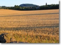
There are miles of excellent walking within the area, either along the river, up local hills, down by the beach, through the woods and along our local path networks or quiet country roads.
There has been an East Lothian Walking Festival held for the last couple of years, with accompanied walks for all both at low level and in the more demanding Lammermuir Hills. Local Ramblers groups are also active and have a thriving programme of events. East Lothian Countryside Rangers have a regular series of events, including walks
There are a number of leaflets available within the village for local walks (The Votodini in East Linton village square has a Tourist Information section)
Since this leaflet was published the John Muir Way has been extended from East Linton to North Berwick, an excellent walk when combined with a return via the bus. If you wish to add anything to this description please email us at: dunpender@electroniccottage.co.uk |